
What is the Karakoram Highway?
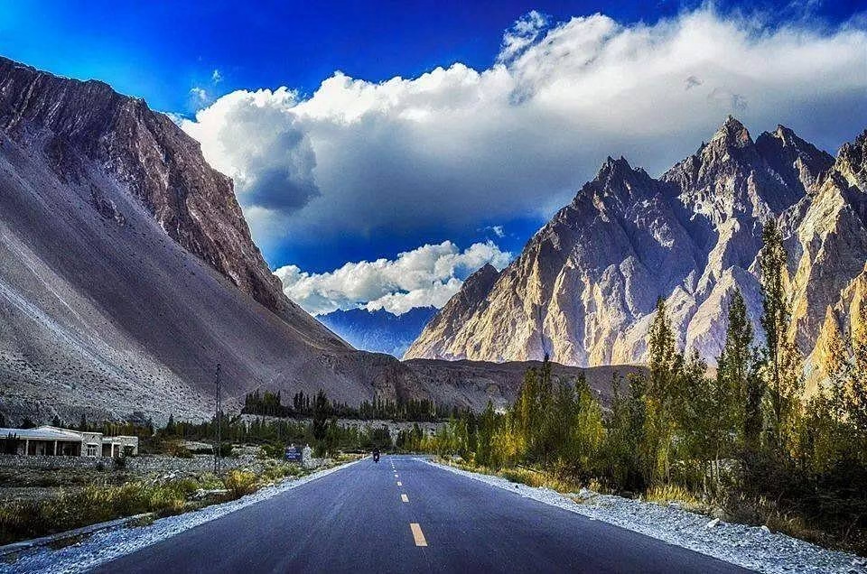
The Karakoram Highway (KKH), officially designated National Highway 35 and locally called the China-Pakistan Friendship Highway, is a 1,300-kilometer road connecting Hasan Abdal in Pakistan’s Punjab province to Kashgar in China’s Xinjiang region. At its highest point — the Khunjerab Pass at 4,693 meters — it is the world’s highest paved international road.
The KKH follows the ancient Silk Road — the network of trade routes that connected China to Central Asia, South Asia, Persia, and the Mediterranean for over 2,000 years. Caravans of camels and horses carried silk, spices, glass, and ideas along this route for millennia. Today the highway carries trucks, tourist vehicles, motorcyclists, and cyclists along the same general path — though in significantly greater comfort and speed than any Silk Road merchant ever managed.
In the modern era, the KKH has taken on additional strategic significance as the land corridor of the China-Pakistan Economic Corridor (CPEC) — a $62 billion infrastructure investment connecting China’s Xinjiang region to Pakistan’s Gwadar Port on the Arabian Sea. The highway has been widened, tunneled, and upgraded in multiple sections as part of CPEC work, though sections remain under construction or seasonal closure.

Construction — Built at an Extraordinary Human Cost
The modern KKH was built jointly by Pakistan’s Frontier Works Organization (FWO) and Chinese engineers over approximately 20 years — construction began in 1962, was completed in 1979, and the road opened to public traffic in 1986. The project represented one of the most challenging engineering feats of the 20th century: building a paved international highway through some of the world’s most geologically active and physically extreme terrain.
The human cost was staggering. More than 1,000 workers lost their lives during construction — approximately 810 Pakistani workers and 200 Chinese engineers — due to landslides, avalanches, rockfalls, flash floods, and extreme working conditions. The fallen workers are commemorated at the Karakoram Highway Monument in Besham, and the road is sometimes referred to locally as the ‘Highway Built on Blood and Bones.’
The geological challenges have not ended with construction. The KKH passes through some of the most seismically active terrain on Earth — where the Indian, Eurasian, and Arabian tectonic plates are actively colliding. Landslides close sections of the road every year. The 2010 Attabad landslide blocked the highway entirely for five years, creating a lake 21 km long that submerged the road. Maintaining the KKH is a permanent, year-round operation.

Key Stops Along the KKH — Northbound from Islamabad
| Stop | Distance from Islamabad | What to See |
| Abbottabad | ~130 km | Gateway to the north; Tarbela Dam nearby; start of mountain scenery |
| Besham | ~260 km | Last major plains-style town; KKH Monument to fallen workers |
| Komila / Shatial | ~460 km | Ancient Buddhist rock carvings and petroglyphs — thousands of them |
| Chilas | ~570 km | Town at junction of three mountain ranges; more petroglyphs; Indus River |
| Raikot Bridge | ~600 km | Turnoff for Fairy Meadows and Nanga Parbat access |
| Gilgit | ~640 km | Regional capital; airport; base for all Gilgit-Baltistan destinations |
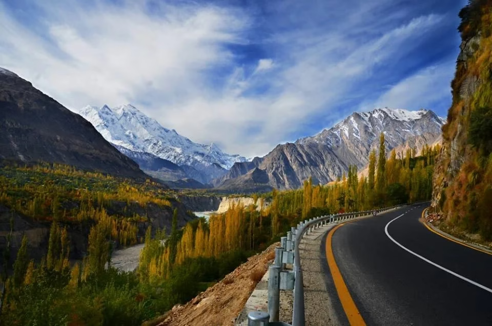
| Rakaposhi Viewpoint | ~680 km | Best roadside view of Rakaposhi mountain — stop essential |
| Karimabad / Hunza | ~720 km | Baltit and Altit forts; Hunza apricot orchards; main tourist hub |
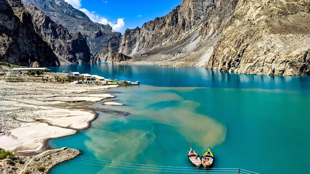
| Attabad Lake | ~730 km | Turquoise lake formed by 2010 landslide; boat rides available |
| Gulmit | ~755 km | Upper Hunza; Passu Cones — dramatic rock pinnacles |
| Sost | ~820 km | Last Pakistani town before Khunjerab Pass; customs and immigration |
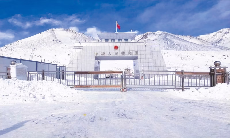
| Khunjerab Pass | ~870 km | 4,693m — world’s highest paved border crossing |
Attabad Lake — Beauty Born from Disaster
In January 2010, a massive landslide in Hunza Valley near the village of Attabad buried 20 houses, killed 20 people, and blocked the Hunza River completely. The water backed up behind the natural dam, flooding 22 kilometers of the original KKH and creating a new lake that swallowed several villages and thousands of acres of farmland. Approximately 6,000 people were displaced.
The lake took five years to achieve a manageable level and for new roads and tunnels to be constructed around the submerged highway section. Today, a series of five CPEC-funded tunnels bypass the lake, and the submerged KKH section remains underwater. What was catastrophe has become one of Pakistan’s most photographed tourist attractions: the lake is a startlingly vivid turquoise — the color coming from rock flour suspended in glacial meltwater — set against the bare, ochre-brown mountains of upper Hunza.
Boat rides on Attabad Lake are available from local operators for approximately Rs 500–1,000 per person. The contrast between the electric blue water, the dark mountain walls, and the occasional submerged tree or rooftop visible through the clear shallow water near the shore creates a surreal and beautiful landscape. Best visited in morning light when the color is most intense.
The Khunjerab Pass — Top of the World
At 4,693 meters (15,397 feet), Khunjerab Pass is the world’s highest paved international border crossing — the point where Pakistan ends and China begins. The name comes from the Wakhi language: ‘Khun’ meaning blood and ‘Jerab’ meaning drainage channel — a reference to the historical attacks on Silk Road caravans that occurred here when bandits controlled the pass. Today it is peaceful, spectacularly scenic, and one of Pakistan’s most visited tourist spots.
The surrounding Khunjerab National Park is one of Pakistan’s most important wildlife sanctuaries. Marco Polo sheep — one of the world’s largest wild sheep, named after the Venetian traveler who first described them — roam the plateau in significant numbers. Snow leopards, brown bears, wolves, and ibex also inhabit the park. The Marco Polo sheep have been a source of both conservation success and controversy — trophy hunting permits were issued in earlier decades, though conservation programs have generally strengthened the population.
The pass is open from May 1 to November 30 each year. Pakistani and Chinese nationals may cross into each other’s territory here; most foreign nationals require special documentation beyond standard visas for this border crossing — verify requirements well in advance.
Chilas Petroglyphs — The Silk Road’s Ancient Archive
Between Chilas and Komila, along a roughly 50km stretch of the KKH, the rocks beside the road are covered with thousands of ancient carvings — petroglyphs inscribed by Silk Road travelers, Buddhist pilgrims, nomadic herders, and local communities over a period of approximately 2,000 years.
These carvings are extraordinary. They depict Buddhist stupas and deities, ibex and other wildlife, camel caravans, mounted warriors, geometric symbols, and inscriptions in several ancient scripts — Kharosthi, Brahmi, Chinese, Sogdian, and others. They are a direct physical archive of the Silk Road’s human and cultural traffic: a layered record of who passed through this narrow gorge, what they believed, what they transported, and what they wanted to commemorate.
Several sites are accessible directly from the KKH with minimal effort. The Oshibat and Shatial sites are most accessible for non-specialist visitors. The Chilas Museum has some context for the carvings. For those with specific interest in Silk Road history or Buddhist archaeology, a local guide who specializes in the petroglyphs transforms what might seem like rocks into an astonishing historical record.
Travelling the KKH — Practical Guide 2026
Getting There and Along
- From Islamabad to Gilgit by bus: NATCO (National Transport Corporation) operates overnight coaches. Journey time approximately 18–22 hours depending on road conditions. Cost approximately Rs 1,500–2,500.
- From Islamabad to Gilgit by air: Domestic flights (PIA, Serene Air, Air Sial) take approximately 45 minutes. Cost approximately Rs 8,000–15,000 return. Flights are frequently delayed or cancelled due to weather — never rely on this route for time-sensitive connections.
- By private vehicle: The KKH can be driven in a standard car from Islamabad to Gilgit. Beyond Gilgit, a 4WD vehicle is strongly recommended for side trips and the highway above Hunza.
- By motorcycle: The KKH is one of the great motorcycle routes of the world. Bring appropriate tools, spare parts, and be prepared for lengthy sections without fuel.
Permits and Restrictions
- Most of the KKH is freely accessible to foreign tourists with a valid Pakistan tourist visa.
- For some areas near the Chinese border (Sost and beyond), a No Objection Certificate (NOC) from the Ministry of Interior may be required. Check current requirements with your tour operator or the Pakistan Embassy before travel.
- Khunjerab National Park entry fee: approximately Rs 200–500 per person.
Best Season for KKH Travel
| Season | Conditions | Recommendation |
| April–May | Road opens, some sections may have damage from winter | Good for early season; fewer tourists |
| June–August | Best weather; all sections open; peak tourist season | BEST — plan accommodation in advance |
| September–October | Excellent weather; autumn foliage; fewer tourists above Gilgit | Excellent choice |
| November | Late season; upper sections may close with first snowfall | Late season; uncertain above Hunza |
| December–March | Khunjerab Pass closed; upper KKH may be impassable in sections | Not recommended above Gilgit |
1 comment
Keep up the great work, I read few posts on this site and I believe that your web blog is really interesting and contains sets of superb information.