
The Great Fort — Overview
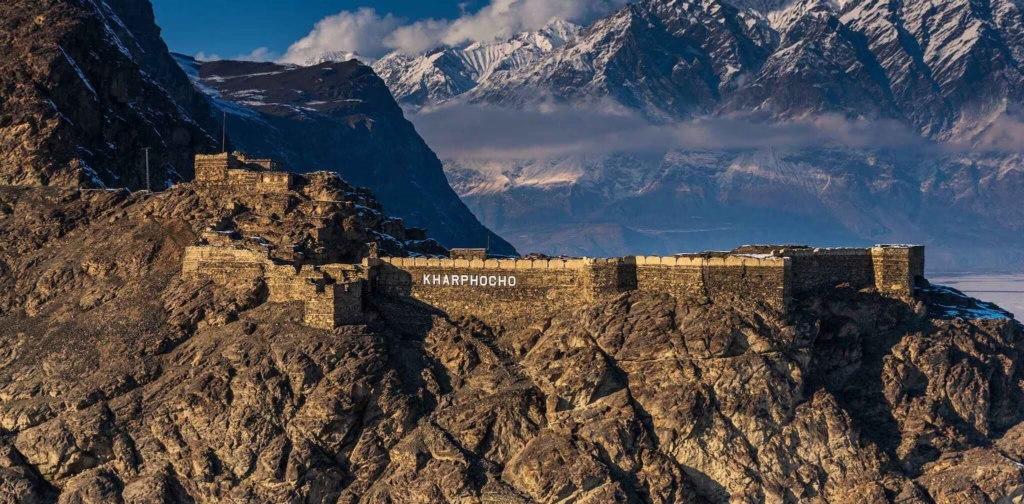
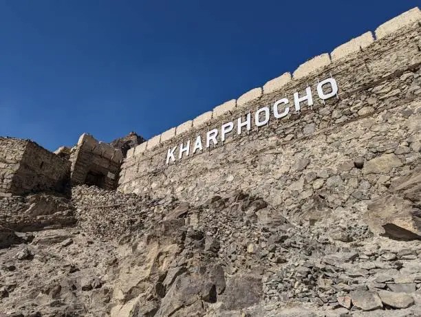
Kharphocho Fort (from Balti: Kharpu = fort, Cho = great — literally ‘The Great Fort’) is one of the most dramatically positioned historical structures in Pakistan. It occupies the summit of a massive, isolated rock outcrop rising approximately 150 meters above the floor of the Skardu Valley, at the point where the Indus and Shigar rivers converge. From below, the fort appears to grow directly from the rock — a natural and man-made elevation so perfectly combined that it is impossible to tell where geology ends and architecture begins.
Built in the 16th century by Ali Sher Khan Anchan — universally regarded as the greatest king in Baltistan’s history — the fort served as the administrative and military capital of a briefly unified Baltistan. For a few decades under Ali Sher Khan Anchan’s rule, most of the independent kingdoms of the Baltistan region were brought under single control for the first and only time in recorded history. Kharphocho was the seat of this briefly unified power.
The King Who Built It — Ali Sher Khan Anchan
Ali Sher Khan Anchan is the most celebrated figure in Balti history and folklore. A king of the Maqpon dynasty who ruled in the early 16th century, he united most of Baltistan through a combination of military skill, diplomatic genius, and personal charisma. His military campaigns extended Balti influence into Ladakh, Chitral, and the Kashmir approaches. He built or strengthened forts throughout the region, institutionalized Islamic law in Baltistan, and is credited in oral tradition with the construction of the famous ancient polo ground at Skardu — polo having been one of the central cultural practices of the Balti nobility for centuries.
Most significantly for Kharphocho’s historical record: during Ali Sher Khan Anchan’s reign and under his successors, the fort successfully resisted multiple Mughal attempts at conquest. The Mughal Emperor Akbar, who incorporated most of the subcontinent into his empire, was never able to take Baltistan. Kharphocho’s position — sheer cliffs on three sides, a single narrow approach path on the fourth — made it defensible beyond the capabilities of Mughal siege technology. The fort was never taken by force.
What to See at Kharphocho Fort
The Approach and Climb
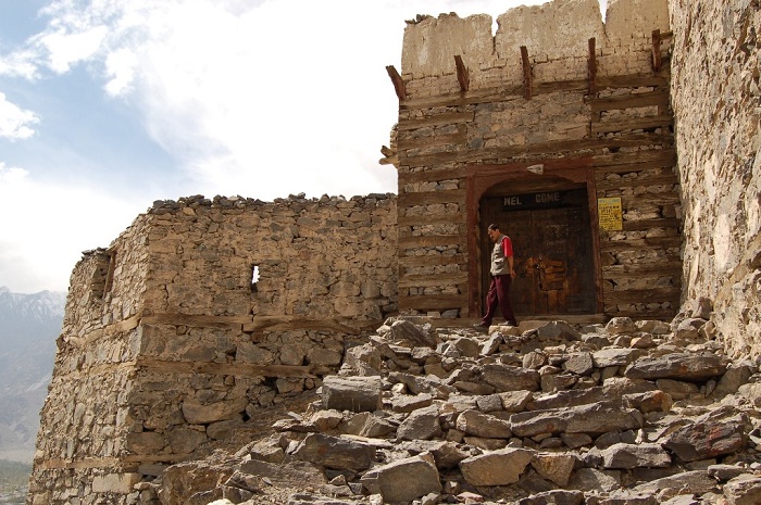
From Skardu city center, Kharphocho is visible on its rock from almost everywhere in the valley — a jagged outline on the skyline that inevitably draws the eye. The fort is approximately 2km from the main bazaar by road. At the base of the rock, a stone path — partially original, partially restored — winds up the rock face in a series of switchbacks to the fort entrance. The climb takes approximately 25–35 minutes for most visitors at a moderate pace. Comfortable walking shoes are sufficient; the path is not technical.
The Fort Itself
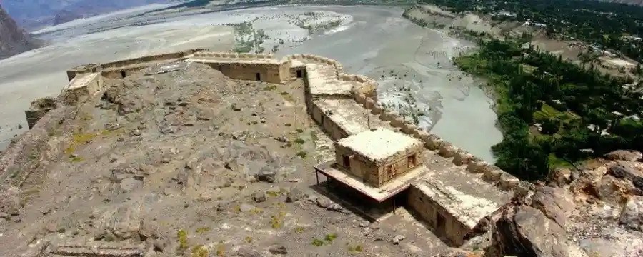
The surviving structures within the fort include: a mosque believed to date from the 16th century, showing distinctly Tibetan architectural influences in its wooden construction and proportions (a reminder that Baltistan’s pre-Islamic culture was Tibetan-Buddhist); the main defensive tower, partially collapsed but structurally significant; storage chambers cut into the rock; the ruins of residential quarters; and the defensive outer walls.
Much of Kharphocho is in a state of picturesque ruin rather than full preservation. Unlike Baltit Fort in Hunza, which underwent comprehensive restoration in the 1990s, Kharphocho has received more limited conservation attention. The ruins are authentic — these are actual medieval structures slowly returning to the rock from which they were built, not reconstructions. This gives the fort a different character from Baltit: less informative as a museum, more powerful as a raw historical presence.
The View — The Real Reason to Visit
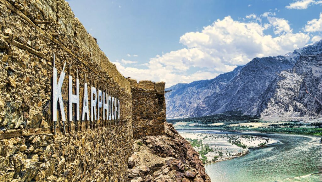
Standing at the summit of Kharphocho Fort, the view of the Skardu Valley is the finest panoramic viewpoint in Skardu district and arguably one of the finest in all of Gilgit-Baltistan. The broad, sandy floor of the valley stretches 30 kilometers in each direction. The Indus River makes its wide meander below, flanked by poplars and agricultural land. The ring of mountains surrounding the basin — the Karakoram peaks to the east, the Himalayan foothills to the south — creates an amphitheater of extraordinary scale.
On a clear day — which in Skardu in July and August means most days — K2 is visible far to the east as a dark pyramid above the intervening ridges. This is the same K2 that requires a week’s hard trekking to reach on foot; from Kharphocho’s summit, you can see it from a comfortable viewpoint in a city with hotels and restaurants a 5-minute walk away.

Visiting Information
| Detail | Information |
| Location | ~2 km from Skardu bazaar; visible from throughout the city |
| Access | Taxi or tuk-tuk to base (~Rs 200–400); 25–35 min walk up stone path |
| Entry fee | Currently free (no formal ticketing) |
| Opening hours | Dawn to dusk; no restrictions |
| Best time | Early morning or late afternoon for photography; avoid midday harsh light |
| Allow | 2–3 hours total including climb and views |
| Footwear | Comfortable walking shoes sufficient; no technical equipment needed |
| Photography | Excellent from summit; bring wide-angle lens for valley panorama |
| Combined visit | Pair with Skardu Bazaar, Upper Kachura Lake, or Satpara Lake on the same day |
Historical Context — Baltistan’s Place in Asian History
Skardu and Baltistan generally occupy a position in Asian history that is far more significant than their current low international profile suggests. This was a major node on the Silk Road — the trade route that connected China to Central Asia and beyond. Buddhist pilgrims from China passed through on their way to sacred sites in India, leaving carvings on rocks throughout the region. The Mughals fought repeatedly to control the strategic passes. The British Great Game of the 19th century — the competition for influence between Britain and Russia across Central Asia — had a significant chapter in Baltistan.
Ali Sher Khan Anchan’s Kharphocho Fort was therefore not a remote provincial outpost but a strategic position on one of Asia’s most contested routes. Understanding this context transforms what might appear to be a ruined fort on a rock into something much more: a surviving witness to 500 years of Asian geopolitics.
1 comment
You have brought up a very good points, thankyou for the post.