
Why Neelum Valley Is Pakistan’s Most Underrated Destination
Ask any Pakistani travel writer to name the country’s most beautiful valley, and Neelum comes up in almost every answer. Yet foreign travelers rarely visit. The name recognition simply is not there in the way that Hunza and Skardu are known internationally. This discrepancy between quality and recognition makes Neelum Valley, in practical terms, one of the best-value travel experiences in Pakistan: extraordinary natural beauty with a fraction of the tourist infrastructure crowds.
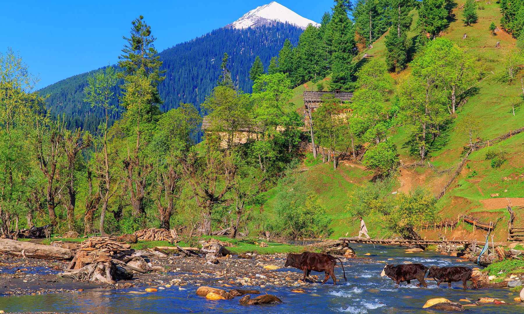
The Neelum Valley follows the Neelum River for approximately 200 km from Muzaffarabad northeastward through Azad Kashmir. The river itself is the defining feature: a vivid, almost electric shade of green and blue produced by glacial meltwater, it runs fast and cold through a valley that narrows and deepens as you travel northeast. Pine and silver fir forests cover the slopes on both sides. Waterfalls appear around every other bend. Alpine meadows open above the tree line to reveal dramatic peaks of 4,000 to 5,000 meters.
At the northeastern end of the valley, the Pakistani territory of Azad Kashmir meets the Indian-administered Jammu and Kashmir across the Line of Control. In the village of Keran, Pakistani and Indian Kashmiri communities are separated by only the width of the Neelum River, and villagers on opposite banks who once belonged to the same families now live in different countries. This political geography gives Neelum Valley a dimension of human complexity and historical tragedy that most mountain valleys lack.
Neelum Valley at a Glance
| Detail | Information |
| Territory | Azad Jammu and Kashmir, Pakistan |
| Gateway city | Muzaffarabad (Azad Kashmir capital) |
| Valley length | Approximately 200 km from Muzaffarabad to Taobut |
| Distance from Islamabad to Muzaffarabad | Approximately 140 km (2 to 3 hours) |
| Best season | May to October for valley travel; some higher areas June to September only |
| Primary activity | Scenic drives, hiking, lake visits, cable car, camping |
| Language | Kashmiri (Koshur), Pahari, Urdu widely spoken |
| Special consideration | Foreign nationals need to check current travel advisories for Azad Kashmir |
Arrang Kel: The Sky Village Accessible Only by Cable Car
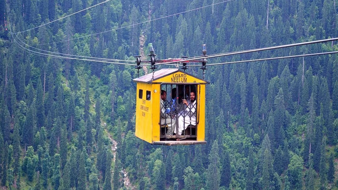
Arrang Kel is the single most photographed destination in Neelum Valley and justifiably so. The village sits at approximately 2,400 meters on a broad mountain terrace above the Neelum River near the town of Kel, 162 km from Muzaffarabad. What makes it extraordinary is the access: the only way to reach Arrang Kel is by a cable car that crosses the Neelum River gorge from Kel town below.
The cable car ride takes approximately 8 minutes and the sensation of crossing above the turquoise river with forested slopes rising steeply on all sides is memorable. The village above is a small community of traditional Kashmiri wooden houses set in a meadow that offers panoramic views of the surrounding peaks. Strawberries grow wild in the meadows. The air at 2,400 meters, even in July, is cool and clear in a way that feels physically refreshing after the heat of the valley road.
Accommodation in Arrang Kel consists of several simple guesthouses and camping areas. The village has electricity via solar panels and a limited food supply. Most visitors spend one or two nights here before returning via cable car to Kel. The walk from the cable car station to the meadow and viewpoints takes approximately 30 to 45 minutes over an easy trail.If you enjoy this kind of off-grid alpine experience, the meadows of Naran Kaghan Valley offer a similarly peaceful escape just a few hours away.
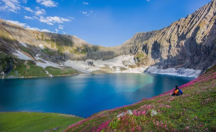
Ratti Gali Lake: Pakistan’s Hidden Alpine Gem
Ratti Gali Lake, at 3,700 meters in the upper reaches of the Neelum Valley near Dowarian, is one of the most beautiful high-altitude lakes in Pakistan. The lake sits in a glacial cirque surrounded by peaks that exceed 4,500 meters. In July and August, the meadows around the lake are carpeted with wildflowers of extraordinary variety. The water is clear enough to see the bottom in the shallows and appears a vivid blue-green from above.
Reaching Ratti Gali from the Neelum Valley road requires a combination of jeep track and hiking. The standard approach from Dowarian involves a jeep ride of approximately 30 minutes followed by a 2 to 3 hour hike. Camping at the lake is permitted and is an outstanding experience. Several tour operators in Muzaffarabad offer guided overnight trips to Ratti Gali. The lake is inaccessible before June and after October due to snow.For more high-altitude lake experiences across Pakistan, the glacial lakes around Gojal Valley in Upper Hunza are equally breathtaking and worth adding to your itinerary.
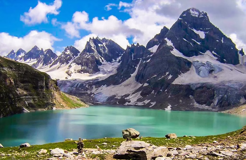
Chitta Katha Lake: Twin Glacial Lakes at the Edge of the World
Chitta Katha, meaning White Snow in Kashmiri, is a complex of twin glacial lakes set in a dramatic high-altitude valley near Kutton, approximately 85 km from Muzaffarabad. The lower lake sits at approximately 3,400 meters and the upper lake at around 3,700 meters. The approach requires a strenuous hike of 3 to 4 hours from the roadhead. The reward is a landscape of surreal beauty: white quartzite rocks surrounding crystal-clear lakes with permanent snowfields on the peaks above.
The lakes are less visited than Ratti Gali partly because the approach is more demanding and partly because they are less well known internationally. For experienced hikers, Chitta Katha represents one of the finest day hikes in Azad Kashmir. Camping overnight allows for summit views in morning light that are extraordinary. Hikers planning a broader northern Pakistan trekking trip may also want to explore the trails covered in our guide to Khunjerab National Park, where the scale and wilderness feel equally remote.
Keran: The Village Split by the Line of Control
Keran, approximately 85 km from Muzaffarabad on the Neelum Valley road, is a village that sits directly on the Line of Control, the de facto border between Pakistani-administered Azad Kashmir and Indian-administered Jammu and Kashmir. From Keran, the Indian side of the Neelum River and the Indian Kashmiri village of Tithwal are clearly visible across the water.
This proximity gives Keran a dimension that is absent from most travel destinations. Some residents of Keran have family members who ended up on the Indian side of the Line of Control when the division happened in 1947. For decades, families separated by 50 meters of river could see each other across the water but could not meet. The emotional weight of this geography is palpable when the local history is understood. For more context on the deep historical layers of Pakistan’s northern regions, the 7 Historic Forts of Gilgit-Baltistan piece is a compelling companion read.
Keran town has guesthouses, a small bazaar, and a bridge viewpoint over the river that gives the clearest view of the Indian bank. Traveling to Keran and beyond toward Kel and Taobut requires crossing military checkpoints where foreigners must show passports. The process is orderly and the checkpost officers are generally professional and courteous.
How to Get to Neelum Valley
The starting point for Neelum Valley is Muzaffarabad, the capital of Azad Kashmir. Muzaffarabad is approximately 140 km from Islamabad via the Karakoram Highway section and then the Muzaffarabad Road through Abbottabad and Mansehra. The drive from Islamabad takes approximately 2.5 to 3.5 hours depending on traffic.
Public transport from Islamabad to Muzaffarabad is available via regular bus services from Faizabad and Pirwadhai bus terminals. From Muzaffarabad, shared vans run along the Neelum Valley road as far as Kel, stopping at all major points. This is the most economical way to explore the valley for budget travelers. For more flexibility, a private vehicle hired in Muzaffarabad for PKR 5,000 to 10,000 per day is strongly recommended.
For road condition updates and official tourism information, the Azad Kashmir Tourism Department maintains current advisories. Weather and snow conditions for high-altitude lake access can also be checked via Pakistan Meteorological Department.
Frequently Asked Questions: Neelum Valley
Foreign nationals visiting Azad Kashmir including Neelum Valley should check the most current government requirements before travel, as regulations for foreign visitors to Azad Kashmir have varied over the years. As of early 2026, foreign visitors with valid Pakistan visas can generally enter Azad Kashmir but must register at checkpoints and may need a No Objection Certificate from the Azad Kashmir government for certain sensitive border-adjacent areas. Contact the Azad Kashmir Tourism Department in Muzaffarabad for current requirements.
Muzaffarabad is the best base for the lower valley and Chitta Katha. Kel town, approximately 162 km from Muzaffarabad, is the best base for Arrang Kel. Dowarian, approximately 125 km from Muzaffarabad, is the best base for Ratti Gali Lake. Most visitors spend at least 3 to 4 nights in the valley to see all major destinations comfortably.
Neelum Valley has an excellent safety record for tourists within the valley itself. The Line of Control near Keran and Kel has been generally quiet since the 2003 ceasefire agreement. Standard travel advisories from FCDO (for UK travelers) or the US State Department should be consulted and followed. The main practical safety considerations are road conditions (mountain roads require careful driving) and altitude-related health at lake elevations above 3,000 meters.